A proposed planned neighbourhood near the Englishman River in Parksville is a little closer to shovels in the ground.
Parksville council gave first reading to an official community plan (OCP) amendment and a zoning and development amendment bylaw to pave the way for the 800-unit neighbourhood, which would be built out over a decade or more, if approved.
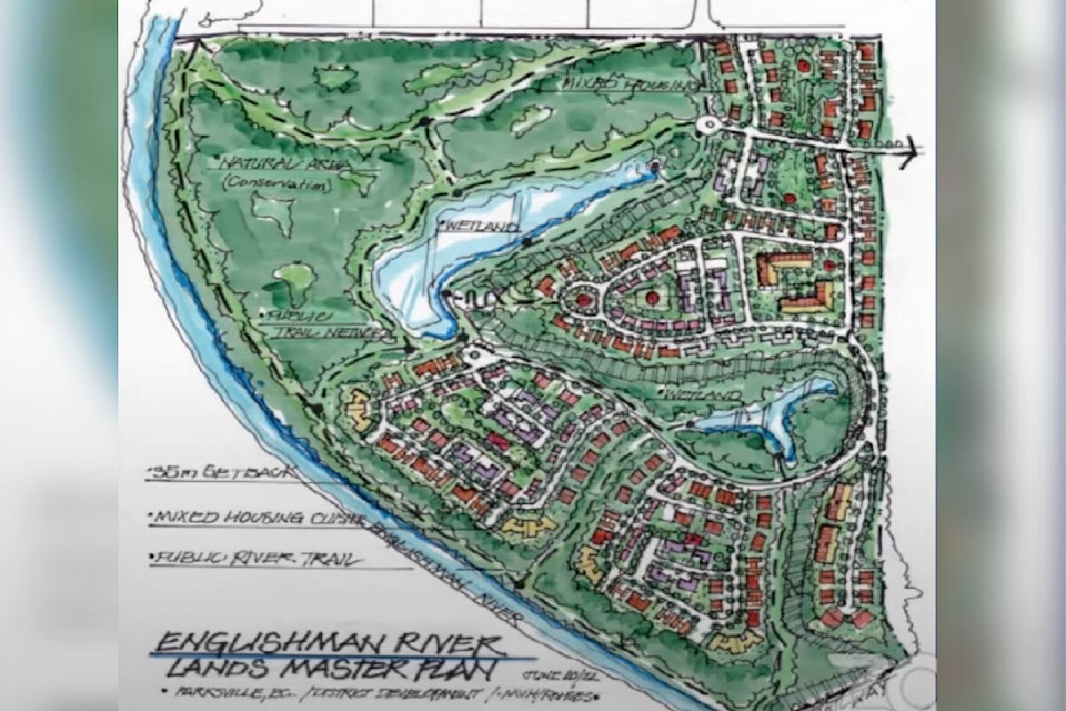
District Developments is seeking the amendments to permit the proposed planned neighbourhood ‘Riverside’ at 1465 Greig Rd., which would be bounded by the Englishman River to its west and south.
The developer wants to rezone the land to comprehensive development and change its OCP designation from single-unit residential and planned neighbourhood to just planned neighbourhood.
The plans call for half of the 140 acres to be developed, while the other half is preserved as parkland and environmental setback.
During council’s July 4 regular meeting, Coun. Marilyn Wilson said she believes there are not enough details in the proposal so far.
“My concern is that the land-use concept should be revisited as part of the City of Parksville’s next comprehensive OCP review,” she said.
Coun. Doug O’Brien said he would like to see a proper trail design for the entire site.
“The Englishman River used to be a salmon-bearing river at one time,” O’Brien said. “It’s not anymore. It’s been abused and there’s various groups that are trying to recover that.”
He also mentioned the river’s estuary and fish hatchery are currently being improved by environmental groups and suggested some of the project’s community amenity contributions could be used in conjunction with those groups’ remediation work.
READ MORE: Two-building, 116-unit Parksville residential development gets first reading
District hopes to rehabilitate the area’s trail network in phases, according to Brandon Crema, executive vice-president. He said some trails are resulting in trampling the side of the river bank, causing vegetation to die and the riverbank to collapse.
Crema said these trails could be moved out of ecologically-sensitive areas to pedestrian- and dog-friendly locations.
In conversations with environmental groups, District was advised to allow the river to regenerate itself, rather than work on it.
Riverside will include duplexes, fourplexes, sixplexes, eightplexes, townhomes, a few small apartment buildings, as well as walk-up three story apartment buildings without elevators, according to Crema.
The reason for the housing diversity is “to be able to facilitate different socioeconomic classes, different family arrangements, different income levels,” Crema said during a presentation to council’s July 4 regular meeting.
District will commit to the first 100 units being rentals, according to Kevin Foster, District vice-president, development and acquisitions.
Foster added District will place a legal document on title that will prevent development in the flood plain, although there will be one caveat that outlines a section called a ‘conditional development area’, where, if District gets a hydrological report that suggests there will be a net-zero impact on flood levels, construction can be considered, if approved by the city.
The development still needs to clear a number of technical steps in both the development and permit process, according to Blaine Russell, the city’s director of community planning and building.
The property is encompassed by five different development permit areas, including a wildfire interface management area, a flood plain, a watercourse protection area, a Douglas-fir and terrestrial ecosystems area and a neighbourhood development permit area.
Michael Nygren, District president and CEO, said a water capacity analysis report found the area has sufficient capacity for both sanitary and drinking water. He added the development was planned with 500-year floods considered.
A traffic impact assessment found the development’s impact on the Tuan Road/old Island Highway intersection is “benign,” according to Nygren, although the intersection will require improvements.
District indicated its anticipated construction start date is July 2023, with an estimated 50 to 80 units built per year.